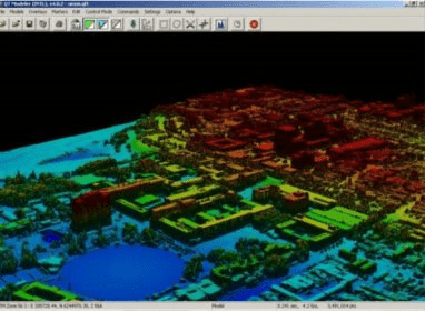
Quick Terrain Modeler is an intuitive software tool that allows the user the ability to see, edit, understand, exploit, and share 3D data.
Quick Terrain Modeler allows you to visualize vast amounts of data using the best data representations for your analysis and exploitation. Quick Terrain Modeler can visualize the points as collected in a Point Cloud, as a gridded surface in a DEM, or display both simultaneously. Once you have the data displayed, the user can enhance the view using visualization tools such as custom lighting, custom elevation palettes, model coloration, and elevation exaggeration.
Build - Quick Terrain Modeler builds enormous DEMs and point clouds from various data formats. Maximum model sizes vary according to available PC RAM resources. The maximum model sizes are provided below for 32-bit and 64-bit PC’s.
Quick Terrain Modeler allows multiple ways to edit your data. The editing tools range from cutting and cropping to isolating individual points in the data, querying and modifying the attributes, and deleting if necessary. These editing tools all take advantage of the ability to view the data that you are editing.
Quick Terrain Modeler allows users to understand their data itself and the context in which it exists.
Quick Terrain Modeler provides exploitation tools that allow the user to analyze their data, adjust planning, and create downstream products.
Quick Terrain Modeler enables sharing of Point clouds and DEMs (created in the Quick Terrain Modeler) through our Quick Terrain Reader as well as exporting analysis and contextual framework with 2-D GeoTIFFs, Google Earth, AVI movies, and Shape Files.

Malwarebytes Anti-Exploit shields browsers and software programs from attacks.
The app includes 27 different modules that enables you to make terrain studies.


Comments